Showing posts with label Arizona. Show all posts

Monday, September 20, 2021

Chapter 11 - New Mexico and Arizona

Quick now. Which state was the 47th admitted?


August 29 - September 1 - We came down from the mountains and stayed at a county RV park in Bernalillo, NM. Nice place, W&E, and great wifi for $25. We ate at a New Mexican restaurant called Arbulita's. Small place, good food. We got there at 11:20 and got the last parking place.


September 2-6 - We moved to an RV park in Albuquerque that we have used almost every year. One of the reasons we came to Albuquerque was to pick up our mail that I had shipped here. I usually have it sent General Delivery to a town that has only one PO. Very convenient, no hassle. I thought since we would be here for several days I would have it sent to the RV park. Well, they were doing a little road work on the interstate exit and the carrier did not want to deal with it, so he quit delivering mail to everyone on the road for two weeks. Several businesses, homes, and an RV park. Complaints that the road was open fell on deaf ears, the kid did not have the through rain and sleet and snow creed. He finally relented today. Government worker and did not get fired!

Another reason to be here is to eat at three New Mexican restaurants. I am not sure what the term New Mexican really means. One thing is that every dish is offered with either red or green chile sauce. Being that NM is the chile capital of the US, the sauces are damn good.

Still up in the air about staying out or heading home. The last few days have not been bad. Could it have been the altitude - we were above 8,000 for over a month. Maybe my misshapen red blood cells had problems with the altitude?

You folks back east have probably long forgotten about the forest fires in California. We see smoke every day, sometimes as dense as a bad pollution day in Birmingham in 1960. 

We seldom stay in RV parks. This year has been the exception. First for the heat dome, now because I wanted to descend to a lower elevation and that meant electricity for ac. 

We get a kick out of the newbies setting up after they park. A couple in a new Airstream took over an hour to hook up. Almost two hours to get ready to leave.

We have noticed that almost all the new 5th wheels and trailers are gray, black, and white. Camping World next door to where we are staying has no other color schemes.

In other RV observations, we are seeing more than a few B+ rigs on the Mercedes chassis. The owners opt to spend $50,000 more to "upgrade" from a Ford chassis. What do they get besides prestige? I suspect the handing is suburb. I know the cost of maintenance is several times what the Ford would be. I suspect the reliability is poor like most every MB made.

I decided this morning to continue the trip and continue west Tuesday. I have been doing OK the last week. And who knows if I will be able to travel next year.

Tuesday, September 7 - Dear Blog, we got away by 9 and headed south on I25 turning west on US60 headed for Datil Wells. This place had been on my list for years. There is nothing there. But people go. I decided I wanted to go just because. Besides, it was a new way to get to Arizona and it was through some mountains.

Dorothy drove for a while and I used the time to study the large-scale New Mexico map. My eye was drawn to a road with many switchbacks. I noted there was a campground at the base of the mountain. So I plugged Water Canyon into our route. It seemed an agreeable place, so Dorothy fixed lunch and we had a nap after our long 2.25-hour drive. After lunch, we drove the seven-mile many switchback road up to 10,500 and had a great view. Not picture-worthy due to it being another California fire smoke day.

So why the road? What's on the top of the mountain? It seems that back in 1980 some professor at UNM convinced Congress to fund building an observatory and atmospheric research facility. It was not open, but what is these days? I suspect smoke from fires might have some effect on stargazing.

Wednesday, September 8 - We got away a 7 to drive to the highway to get cell service so we could surf. Dorothy made breakie while I checked mail. We paused at the Very Large Array. A sign noted the VC was 4 miles down a dirt road and it was closed. 

We continued 10 miles to Datil where there is a really great BLM CG. Three sites have electricity. The camp host said it is experimental. We have a large level site with ramada and juice for $2.50. The downside is no usable cell signal, even amplified. The CG even has a small VC. But it is closed Tuesdays and Wednesdays. Isn't everything?

History lesson. In the later part of the 1800's the route US60 traces was a cattle/sheep driveway from Springville, AZ  to Magdalena, NM, where the stock could be loaded on a train. About every 10 miles there was a well. Datil Wells was one of the wells.

We did the tourist thing and had lunch, a green Chile cheeseburger, at the gas station, general store, RV park, and restaurant complex. It turned out that the restaurant served pretty good food.

We noted that many of the gas customers were in camo. It was opening day for Elk taken with a bow.

Thursday, September 9 - Based just on a remark made by a guy at the restaurant yesterday, we went a little out of our way to Arizona by way of Reserve. It was a rewarding drive with an ever-changing landscape. There were vast flat plains, probably ancient lakes, now used by grazing cattle and elk. The forest floor south of Springville in the Luna Valley is beautiful.

Only in New Mexico

No passing areas have the usual yellow lines, but also signs on both sides of the road announcing No Passing. The zone is terminated with a single sign Pass With Care. So three signs every time. I wonder how many thousand signs there are in the state? Locals ignore the signage.

Vehicles used in highway construction, ambulances, etc. have red and blue emergency lights. LEO vehicles use red only. I think NM is the only state to use those color combinations.

Pull offs are rare, road shoulders are narrow.

Friday, September 10 - We drove around to see what was around us. We had heard about a restaurant in Greer that serves prime rib. It must be really swell beef as they want $35 for the small prime rib. It will be a cold day before I pay that much. We buy it on special at home for $6.99 a pound. Dorothy ages it for 10 days and we enjoy it. The grand dog gets the bone which she enjoys for the 15 minutes it takes her to pulverize it.

We found a fine dispersed camping site and moved our home. We are parked in a meadow with yellow and purple flowers. We now have sun for charging the batteries, can run the genset before 8 to make waffles and save $12 a day. That said it was a superb Forest Service campground.  

Our afternoon entertainment was being in a cattle drive. Two cowboys with two cattle dogs were moving a herd of about 100 beeves down the road. The beeves preferred the meadow to the road, surrounded us, and mooed loudly and for a while resisted the cowboys whoops to move along. I thought Oh Boy Prime Rib!


After finding that Page, AZ will be in the high 90's for the next 10 days we have changed our plans. We will hang in the Arizona mountains between here and Flagstaff until it cools off some.

In other news, we have been above 8,000 feet for the last four days and I am not experiencing the low energy days I was having two weeks ago. Perhaps the elevation was just a coincidence.

Saturday, September 11 - Yeah, it's that day again. It was 46 this morning. 

We needed a few groceries and I wanted to check out the Casa Malpais Museum, being only one letter different from my name. Malpas is bad pass or bad step. Malpais means badlands.

The museum, named for a nearby pueblo, was more than expected. While the few artifacts from the dig were interesting, the rest of the museum was of more interest to us. Art and history.

Springerville and Eager adjoin. There is a marked difference between the two. We guessed due to LDS. Turned out that a Springerville resident believed that Mormons could not be killed due to their sacred underwear, so he shot one. That led to the town of Eager being founded by LDS.

Sunday, September 12 - It was warmer this morning, a low of 50. We took a short drive on 273 seeking scenery. We got it, but it was all the same. We went up a thousand feet and were on a vast flat plain. Spent the afternoon reading and vegging.

Monday, September 13 - File under what you don't know can mess you up. We left our pleasant boondock near Greer and headed west in search of new vistas. I did not know we would be losing so much elevation - the natural ac. By the time we got near Show Low, we had lost 1,200 feet. It was warm and we needed electricity.

The other thing I did not know was that we would leave the rural forest and be in a tourist destination. Miles and miles of stores along the highway from Lakeside to Show Low.


There were fields of these flowers for several miles

My outdated guide to public campgrounds led us to a campground that has been closed since 2017. We wound up in the Show Low city park. That would not be so bad, but it's managed by RRM which has to be the absolute worst concessionaire going. I know the owner Warren Meyer, by reputation. This is our third or fourth experience with RRM and they have all been dismal. Mr. Meyer must have a talent for only hiring pompous assholes to manage the campgrounds.

Tuesday, September 14 - Today I learned that just because it's called Rim Road does not mean you will peer over the Mogollon Rim. We entered the Rim Road on the east end and drove past summer home after summer home until we saw a dead-end sign, which was followed by some mega-mansions and finally a gate to even more homes. Perhaps some of these homes were on the rim. I will never know. I decided to try the west end of the road. After driving miles, we came to another gate. This time it was the Apache that promised we would be stretched out over an ant bed if we proceeded. So much for the Rim Road near Show Lo.

Show Lo was named because the two owners of a ranch decided it was only large enough for one of them. To decide who would take control of the ranch they played cards. The game was not decisive. So one of them said if you can show low you win. The player flipped over the deuce of clubs, the lowest ranking card, and won the ranch. There is a street named the Deuce of Clubs.

Wednesday, September 15 - We moved west an hour and parked in the largest Forest Service campground I have ever seen - Canyon Point. There are 100 sites widely spaced. Most are pull-throughs with enough room to park several RV's. Great campground except, like most Forest Service campgrounds, there are too many trees to allow enough sun to reach the solar panels.

We checked out two other FS CG's in the vicinity and several boondock areas. We found one dispersed area on another Rim Road that has a few sites that should allow us enough sun.

We found one place where we could look over the rim. We could see nothing but trees all the way to the horizon. Well, trees and California fire smoke. It looked like the Blue Ridge mountains. 


This is the Rim. Not Much Huh?


What we saw from the rim looking out 25 miles - Smoke from California


The next day - an improvement

Thursday, September 16 - We moved to a place on the rim where we have 1) Sun, 2) an overlook over the rim, if we walk 50 yards to the rear of our site and 3) interesting neighbors.

1,500 feet of wind hits the rim wall and is forced up providing a cool breeze.

We drove some of the rim roads and found a great spot to park, but it's too far down a rough road for KoKo. There are hundreds of dispersed places. Most are marked "Park Here". There are even Forest Stewards that drop by and advise you on forest rules, like fires only in fire pits. Never encountered that before.

Friday, September 17 - We did a short drive on the west rim road. Frankly, the views from Shades Crest Road in Birmingham are better. I am sure the view would be greatly improved without the California smoke. I am calling the Rim not worth seeing after looking so forward to it. 

This place is popular with the Phoenix crowd. Phoenix is only two hours away. 111 degrees there. 82 here.

At the campground, they had a dump and trash disposal. There was a volunteer couple collecting money to dump $7 and for trash $3. We had a soccer ball size trash bag. I passed on paying three bucks. I can not imagine having my RV parked at a dump and standing up all day collecting cash.

Saturday, September 18 - We read our books. The sky changed from overcast to full sun several times during the day. There were sprinkles of rain a few times.

Sunday, September 19 - We descended from 8,200 to 3,500. Oh yeah, it's warmer. We want to drive a trail near Sedona. Hope we will not roast.

We stayed at Dead Horse Ranch SP in 2007. $30 a day for W&E. The park has several loops that make it seem not so crowded.

Monday, September 20 - I made blueberry pancakes this morning since we had electricity. We got away to Sedona to drive the Schenbley Hill trail. The trail was scenic and rough. Getting on the trail before 8:30 we missed the traffic. Just a few of the Pink Jeeps that make a living hauling fat cheesy tourists at double the speed I drive, 5mph, on such trails.


Around Sedona

We did not go the entire trail. As we exited the red rock area I decided the fuel gauge indicating empty meant we should turn around. I had to drive 8 miles once we got back to Sedona to get to a gas station. There are only a few in town. No room for them due to restaurants.

We had lunch at an Indian restaurant. We thought it was the same one we went to in 2007. It was good and quite expensive.

Tomorrow is my birthday - again.


One of a pair on a private drive


Wednesday, May 10, 2017

On The Strip

The strip refers to northern AZ and southern Utah

 The Blue Bird Of Happiness?

Thursday, May 4
Dorothy made scrambled eggs and chocolate milk for breakie. The eggs had a dark appearance. I asked her what she put in them. She said “Onions.” I said “And what else, dirt?” She started laughing and continued laughing. Finally she said “I messed up and put chocolate in the eggs.”

We took the 27 mile loop from Sunset Crater NM to Wapatki AZ. The former is a huge lava field. It’s not unlike Craters Of The Moon in Idaho or Newberry in Oregon. We thought it was more photogenic than the former, but did not take a single picture. Geesh it’s lava. Enough for a zillion BBQ grills for a gazillion years.

We found Wapatki most interesting. Several pueblo Indian ruins. They were intact when the Mormons passed through as they did drawings of them. The Hopi built them, left them and the Navajo took up residence until the Blue Coats ran them off. During prohibition moonshiners were using them and tore down many of the walls down to combine rooms. The sheriff could not root out the moonshiners so the Feds were invited to make it a monument and enforce the laws. The feds were particularly nasty in running off the remaining Indians who had been given permission to live there until their death.


 Wapatki AZ.

What a difference a hour can make. We woke up in a quiet pine forest and parked just after lunch on the beach at Lake Powell. Tahoe is a splendid scenic lake, but we favor Powell. Totally different scenery this afternoon. Goodbye green things. Hello red rocks.

 The Beach At Lone Rock On Lake Powell

 Lone Rock


Friday, May 5
It appeared to us that Lake Powell was up considerably. We Googled and saw that it has been rising every year the last four years. Rocks ledges across from us where we beached the boats a few years ago are so far under water we could not see them - and the water is clear. We paddled into a canyon that has always been dry and plan to return and go farther. 

We noticed that Page seems to have more Indians. Small wonder, since one of the largest reservations in the country borders on the town. The younger ones are easy to spot, they are wearing hoodies in 90 degree temps.

Saturday, April 6
High winds today, gusts to 39, cancelled paddling plans. In the morning we checked out renting a runabout to sightsee the lake and take pictures. The rentals at the marinas are twice the rate for the ones not on the lake. Government concession limits competition. We were OK with the rate, but the Jeep is only rated to tow 2,000 pounds and the boat weighs 3,000. And so it goes. We found another place that also rents a truck to tow the boat, so we are good to go.

We drove a short way on a dirt road and thought we were in Moab. Then we saw a wide paved road with a sign that said only Amangiri. A paved side road in these parts is unheard of, so we turned in and drove a mile or so through rock formations that looked like the Courthouse cluster at Arches. We finally get to a key coded gate with another sign that says only Amangiri. There was also a wind sock and we decided the wide paved road was also an airstrip. We asked a local about it and found it was a resort for swell folks that can afford $1,500 plus a day.
https://www.aman.com/resorts/amangiri 

In afternoon, we went to a car show in town put on by the locals. There were two cars we had never heard of, some classic’s, a few rat rods, etc. We finished our town trip with some of the Best Margaritas In Town. They were only so-so.

Sunday, April 7
The wind is lower, but still kicking up some sand on the beach. Not so much so on the perch above the beach. We turned on the generator so we could vacuum the pink dirt. That took an hour of our morning. The wind had blown one of our kayaks in the water and another kayaker had chased it down for us. We are now known as the people with the boats. Since the wind was still too much for paddling, we did laundry.

Monday, April 8
There was a shower overnight. Probably only lasted a few minutes, but we woke up and saw water on the Jeep. First time we have seen rain reach the ground in southern Utah. The temp dropped to 48.

We paddled the yaks in the morning and read all afternoon.

Tuesday, April 9
It was overcast and the wind was calm when we woke up, per the forecast for today and Wednesday. By 10, the sun was out and a delightful breeze came up. Life was good. We were sitting outside enjoying the weather when the breeze piped up a little and Dorothy suggested we stow the awing. We did. A few minutes later she served stuffed pork chops and we felt the rig shake. I saw a sand storm out the back window. In seconds we were coated, again, with pink sand. We were fortunate that the back end of the KoKo was into the wind, escaping sand coming directly through the windows. An ample plenty came in the sides. We battened down the hatches.  Have to tell you, we had little after taste of the pork chops, just sand in our mouths. We spent 90 minutes vacuuming up the pink stuff. Twice in a week is enough. The temp dropped 20 degrees.

After two sand storms in a week, it makes it easier to understand how the rocks have been eroded. 

Wednesday, April 10
Overcast in the morning and a moderate breeze. We went to town for groceries. Tomorrow is supposed to be good weather for our boat ride. The forecast for the next ten days after that is more wind. That will cancel our planned overnight tent trip into the wilderness. We have digested enough pink sand.

Even with not so great weather we have enjoyed eight days here.


 Her Pick

My Pick

Up A Canyon

 Dorothy Coming To Shore

 The Not So Good, Pink Sand

More Pink Sand


The next edition will be about our boat trip on the lake.

Wednesday, May 3, 2017

Organ Pipe

Sunday, April 23
We stopped at Butterfield’s RV park in Benson for the night. Darn nice park. The only negative would be the proximity to the train tracks. A train went through every 20 minutes blowing its whistle several times. It did not bother our sleep one bit.

Now the good part. They have an observatory. That said, they were the only RV park with one. They have a 16” which we were informed is the smallest professional device. They are commonly used at universities. It's getting better. The man that did the “star talk” was gifted at explaining things in terms we could understand. The program was a little over three hours. 

We looked at Saturn and it’s four moons. Europa was setting behind Jupiter while we watched. Other objects were Proxima, M3, M35 and NGC3242, the Ghost of Saturn.

Monday, April 24
We drove three hours southwest on a not so good two-lane to Ajo, AZ. We are going to spend two days checking out Organ Pipe NM. We should have allocated more days, but I screwed up.  I have a hard time making a schedule.

This afternoon we spent two hours at a local museum chatting with a guy about the history of the former copper mining town and border policy. We would have never guessed the mine owner was connected to so many swells, including TDR. The owner was very progressive, in the old sense. He paid well, built a hospital and schools which look good today 75 years later. 

The "5 C's" of Arizona are cattle, climate, cotton, copper, and citrus. We had seen two or three copper mines on previous trips. This trip we have seen them everywhere. We had no idea there were so many, and many are still in operation.


From Ajo to the Arizona/Utah border

Tuesday, April 25
We got away early and drove the Ajo Mountain Loop. While it’s named for the Organ Pipe cacti (Stenocereus thurberi), the Saguaro (Carnegiea gigantea) greatly outnumber them. And to our eyes have a better appearance.

Wednesday, April 26
We took our time leaving Ajo and arrived at RV Coach Glass in Phoenix after lunch. 

Thursday, April 27
They started work at 8 and finished at 12:30. That’s longer than they took at the place in Florida to screw up five windows. There was a little bit of etching on the glass after two months. 

We escaped Phoenix to a Escapees park in Congress, AZ. We should have stayed in the lot at the glass shop. The Escapees park was a not a dump, but only a few steps up. People actually spend a season there.

Friday/Saturday, April 28/29
We arrived in Prescott. We had no idea it was so peoply. We walked along the lake and got a few pictures. The wind was blowing so no yakking. The boats have yet to get in the water.

We took some more pictures at sunset on Saturday. The wind had died off, but we did not have the time to launch before losing the light.


A Photo club was there also

Rocks and water were not the only going on. There was a National RC Rock Crawler competition

Sunday, April 30
We escaped Prescott. It may not be as bad as Sedona, but we have no reason to return. Having driven 89A to Jerome back in 2007 we knew better than to take that twisty windy downhill road again. So we dropped down into the valley and found a pleasant place to park on Forest Service land. It seems dispersed camping is everywhere the AZ forests. 

Monday, May 1
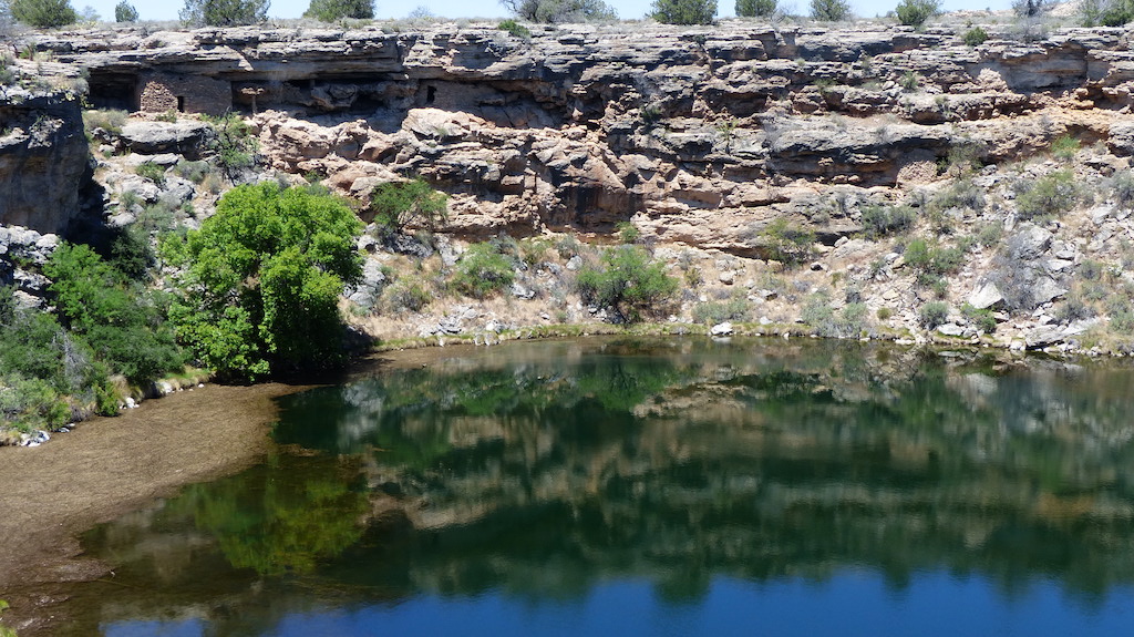
We went a few minutes north to the misnamed Montezuma’s Well. Montezuma was never anywhere near here. We were informed that snow melt on the Mogollon Rim [Muggy On] 10,000 years ago is still seeping to this well. Several million gallons an hour.  Hard to believe, but it is an oasis in the gravel pit. 

The ranger mentioned that the V Bar V ranch was just a few miles up the road and had over 1,000 pictographs. We have seen dozens of walls of pictographs, but he made this one sound special and it was. But only because there was a ranger explaining it. First, the wall is almost on a true north/south axis - that’s necessary for it to work as desired. The Indians placed two sharp rocks in a crevice that acts like a sundial, but for dates, not hours. They etched into the rock face symbols to denote key times of the year, such as a representation of an ear of corn. When the shadow from the inserted rocks points to the corn, it was time to plant. They even have a when to dance symbol after the time to harvest symbol. A good corn harvest was a great deal more important to them than picking up a few ears at the grocery.

Montezuma's Well

The Seasonal "Sundial" The shadows point to symbols that are critical times of the year. For instance, wait until the shadow points to the ear of corn before planting, otherwise risk frost and loss of seed.

Montezuma's Castle

Tuesday, May 2
We moved a little north toward Flagstaff. Glenda wanted to route us 40 miles north on I17 and then 20 miles south to our destination, Morman Lake. The Delorme map showed a much shorter route on a two lane paved road. The map was wrong, it turned to gravel, but we went through some great high pines country. All the formal Forest Service CG’s were closed, so we opted for dispersed again in the pines.

We passed a sign for Lowell Observatory on the Forest Service road but did not check it out.  The storied hilltop center is in Flagstaff is no longer used for research. This one is their Dark Sky facility.

Wednesday, May 3
We made four stops in Flagstaff for various items and planned on staying at a campground at Sunset Crater. But it does open until Friday. So again, we are parked in the pines. This time with Blue Birds that are most interested in looking in our windows. They perch on the window frame and turn their heads to peer with first one eye and then the other. We think they are mystified they can not see in. Right now, the female is perched on Dorothy’s kayak and the male on mine. I should take a picture, but a week worth of volcanic dust covers the rear the window. OK, I got out the California Duster and cleaned the window. Do the Blue Birds return to perch on the yaks. No!

In only a week we have made it from Phoenix to the northern part of the state. After we leave here we will have to go through the Navajo Res to Page. We are about out of water.


Thursday, April 23, 2015

The Rock Trip

We finally came up with a name for this trip. Since almost every stop has been to look at rock formations, The Rock Trip seems appropriate.
14 Moab63Dorothy in our fixer-upper 14 Moab68Gemini Bridges From Below 
Our last week in Moab was marred by bad weather, first high winds, then snow and rain. SLC had a monster late winter storm and Moab got some it.
14 Moab73 14 Moab82
Rain And Snow in Moab
However, on our last day the rain quit, the sun came out and the skies were quite clear, so we were able to drive the whole Poison Spider trail and managed some decent pictures of the Behind The Rocks area. The trail is rated one notch more difficult this year due to heavy use by ATV’s. We had no problems going up, but coming back down, I could not believe the height of ledges we went up. Sometimes they look bad going up, other times they look really difficult going down. Maybe another time, we will have all day so we can continue from Poison Spider to the Golden Spike trail.
14 Moab77 14 Moab79 The very difficult to access Behind The Rocks area from the Poison Spider trail
Trails done this trip: Bull Canyon, Day Canyon Point, Dome Plateau, Fins and Things, Hell Roaring Rim, Hey Joe, Poison Spider, Picture Frame Arch. Drove again to the start of Behind The Rocks and knew we still did not have enough Jeep or the nerve to do it. Dorothy said there was no way she was doing Hell’s Revenge. Maybe another time. 
Sunday – April 19 – We drove two hours south to The Needles District of Canyonlands. We have been here several times before. We were here last year and did half of the Elephant Hill trail before I chickened out and turned around. NPS is proposing to permit the trail soon, so that effectively means closing it to all but a lucky 10 vehicles a day. So I wanted to give it another shot.
And so we did. We got away at 8:30 and got back at 6 – a LONG day. The Jeep trail looks worse than it is in places. We had no problems. The Rubicon continues to amaze us with what she can do. Much of the trail is through long canyons on smooth dirt. I wanted to do the trail for two reasons, the primary one was to get to Chelser Park. This hiking distance to it is way beyond our endurance. We tried it last year. Looking at the map, it showed we could almost drive to it. In fact, in the parking area at the end of the trail is a sign that shows .6 miles. It does not say to where you will be in .6 miles however. We went twice that distance and still did not get to Chelser Park.
15 the needles22This is what stopped Dorothy, it’s over 40 feet high 
15 the needles26
This is what stopped me. Slipping off the narrow cedar log and breaking a leg on the way back was on my mind. On the next ledge is a large pile of boulders to scramble over.
Oh well, it was both a fund and a scenic drive.
15 the needles06 15 the needles15
What we did NOT see
Chesler-Park-Trail-Canyonlands-National-Park-Utah Pan_CheslerPark1-c3x1-c2_XL
Tuesday - April 22 – We continued south on US191 to Canyon de Chelly. A place that has been on our bucket list for years. We met Mary and David and got caught up with them. I have say that as canyons go, the Indians here had a great home. Not only scenic, but they had plentiful water.
16 canyon de chelly02 16 canyon de chelly15
16 canyon de chelly04  16 canyon de chelly11We are home bound. See you next year.

Trip Stats: 6,500 miles on KoKo. $1,800 worth of gasoline. Parking per night: $6.09. Almost 60 consecutive nights wo hookups.
home-is-wherever-you-park-sign